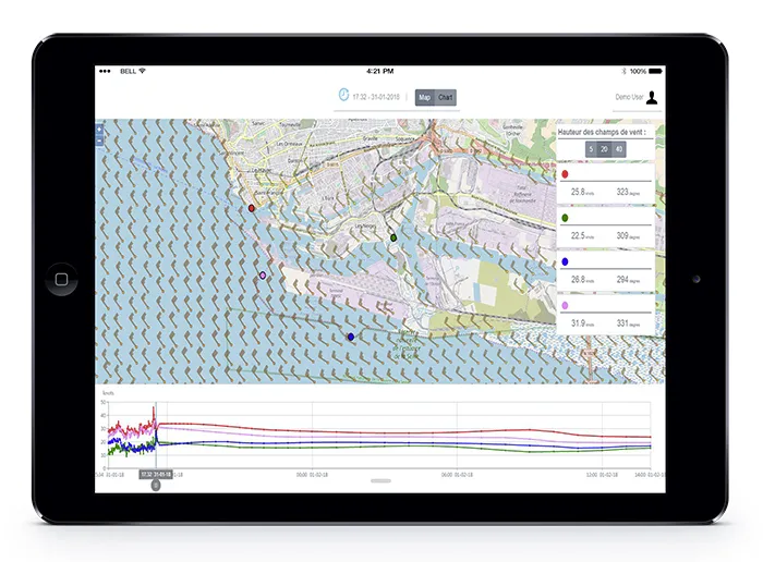
RT Windmap
RT Windmap is a real-time and forecast port wind monitoring application. A true decision support tool, the application secures ship maneuvers and port handling operations by optimizing their organization based on forecast wind conditions.
The application for optimizing port navigation based on wind conditions
RT Windmap provides real-time or forecast wind maps within the harbor and up to 8 nautical miles offshore. The application accurately displays wind direction and speed with a horizontal resolution of 10 to 50 meters, covering a time scale from minutes to several days.
Tailor-made for each port, the application incorporates local aerodynamic effects caused by topography, buildings and vegetation into its calculations and combines them with meteorological forecasts to produce highly accurate wind maps.
The wind conditions in the port are estimated with:
• Weather forecasts
• On-site measurements
• Computation of building and local topography effects
• Integration of a self-learning statistical model
The RT Windmap application is the winner of the 2021 Port of the Future Trophy.

Organize and secure port operations in windy conditions

Decide
Use forecast data to easily plan handling activities based on wind conditions.

Secure
RT Windmap also alerts handlers in the event of high winds, prompting them to suspend handling operations.

Optimize
Increase productivity by staying informed about wind conditions and ensure a smooth workflow by optimizing the scheduling of handling tasks and the required human resources.

Protect
Ensure the safety of vessels, freight and staff.
Improve handlers’ working conditions and minimize incidents.
Strengths
Designed to meet your needs
Whenever possible, we use existing wind measurement points in the harbor to improve the accuracy of very short-term forecasts.
Available on multiple devices
Data storage that enables replay of event scenarios
Dedicated team to assist with setup and ongoing support
High availability of data delivery.
This allows you to monitor the wind in real time.