← Return
Vattenfall validates SARWind® TIMESERIES at one Offshore Site in the North Sea

Vattenfall validates SARWind® TIMESERIES, wind resource assessment data based on SAR satellite observations, at one North Sea Offshore Site
Conjointly developed by Meteodyn and CLS, the SARWind® TIMESERIES service offers long-term, high-resolution wind data dedicated to offshore wind farm developers for wind resource assessment studies.
PRESS RELEASE, February 2026
Saint-Herblain, France
Vattenfall has independently validated the SARWind® TIMESERIES service, designed by CLS and METEODYN, at a met mast in the North Sea. This validation follows a five-year benchmarking period against mast measurements. It confirms the high accuracy and value of SARWind® for offshore wind resource assessment. Download the press release
A validation following a five-year benchmarking period against measurements
Vattenfall, one of Europe’s largest producers and retailers of electricity and a company committed to fossil freedom, has independently validated the SARWind® TIMESERIES data.
This validation follows a five-year period benchmark (2018–2022), during which METEODYN provided Vattenfall with hourly wind speed and direction time series at a height of 100 meters, derived from satellite-based SAR observations, for the entire period.
This data was then compared by Vattenfall to mast measurements at one offshore site in the North Sea. The results of this comparison demonstrate strong alignment with reference data:
| Variables | Difference |
| Correlation coefficient | 0.958 |
| Mean wind speed error | -1.0% |
| Median wind speed error | -1.8% |
| Root Mean Square Error | 1.40 m/s |
| Mean Absolute Error | 1.03 m/s |
| Gross Annual Energy Production (AEP) error (based on IEA-15MW turbine curve) | -0.70% |
High-resolution data: SARWind® TIMESERIES outperforms mesoscale models
This benchmark reveals that SARWind® TIMESERIES notably outperforms mesoscale models by reducing the estimation error of Annual Energy Production (AEP) by 1.42%.
This makes it a more precise and reliable alternative for planning offshore wind projects.
In addition to wind speed, SARWind® TIMESERIES also captures the wind direction distribution and annual and diurnal wind cycles more accurately, providing developers and operators with comprehensive, high-resolution insights.
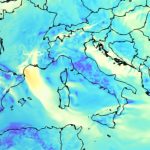
Figure 1: Wind rose of SARWind® TIMESERIES derived from SAR observations

SARWind® TIMESERIES is available to download on METEODYN’s Wind Data Portal: https://meteodyn.com/product/offshore-met-mast-sarwind-northern-europe/
More information about SARWind® technology: https://energies-and-infrastructures-monitoring.groupcls.com/solutions/wind-energy/offshore-wind-resource-assessment-sarwind/
The benchmarking effort and the resulting high correlation with mast measurements clearly demonstrate the robustness and practical value of the solution. This work meaningfully advances the state of offshore wind resource assessment and showcases the strength of the collaboration between Meteodyn and CLS in delivering high‑quality data relevant to the industry.
The development of SARWind® technology began in 2019, based on a technology transfer of satellite data processing techniques to the offshore wind sector. After years of research and development, deployed two years ago, we now have a fully operational and accurate service. Today, SARWind® TIMESERIES is currently finding its market, with three international contracts secured to date: one on the west coast of the United States, one in Estonia, and two in Italy. The data is also available for download via METEODYN’s Wind Data Portal. This benchmark, validated by Vattenfall, confirms the accuracy of SARWind® TIMESERIES and brings the technology one step closer to widespread adoption in offshore wind resource assessment.
More information about Vattenfall
Vattenfall is one of Europe’s leading energy companies. Active in electricity, heating, and integrated energy solutions, the group’s mission is to enable fossil-free living within one generation. Operating in Sweden, Germany, the Netherlands, Denmark, and the United Kingdom, Vattenfall is a major player in offshore wind energy, with one of the largest development portfolios in Europe. www.vattenfall.com
More information about METEODYN
Founded in 2003, Meteodyn is an international company specializing in digital wind engineering, climatology, and meteorology. With more than 900 clients in 50+ countries, Meteodyn is renowned for its Computational Fluid Dynamics (CFD) wind flow modelling expertise. Subsidiary of the CLS Group, Meteodyn is headquartered in Saint-Herblain, France, and has strengthened its international presence with two subsidiaries located in China and in India. Initially focused on the development of wind flow modelling CFD software (such as Meteodyn WT and UrbaWind®), the company now offers multiple software solutions (Meteodyn EC1 — leading web application for wind safety in the construction industry in France — as well as Meteodyn WPA and RT Windmap). The company also provides a wide range of services dedicated to renewable energy, buildings, transportation, power grids, and climate change adaptation (Wind Power Forecasting, Virtual Met Mast, Climate Change Analytics, Wind Load Assessment, Railway Crosswind Safety, etc.). During the past 20 years, the Meteodyn Group has been supporting and guiding professionals in building a sustainable, cleaner, and safer future. www.meteodyn.com
More information about CLS
CLS is a global company, mission-driven, and pioneer provider of monitoring and surveillance solutions for the Earth, created in 1986. CLS is a subsidiary of the French Space Agency (CNES) and CNP, an investment firm. Its mission is to create innovative space-based solutions to understand and protect our planet and to manage its resources sustainably. CLS employs almost 1200 people at our headquarters in Toulouse (France) and in 41 other sites around the world. The company works in five strategic markets: sustainable fisheries management, environmental monitoring, maritime surveillance, mobility, and energies & infrastructures. CLS processes data from 200,000 beacons per month (such as drifting buoys, animal tags, VMS beacons, & LRIT tracking) and observes the oceans and inland waters (every day more than 20 instruments onboard satellites deliver information to CLS on the world’s seas and oceans). In addition, CLS monitors land and sea activities by satellite (nearly 20,000 radar and optical images and several hundred drone flights are processed each year). The CLS Group had a revenue of nearly 220 million Euros in 2024. Committed to a sustainable planet, every day the company works for Earth, from Space. www.cls.fr
Article similaire:
 DeepCLidar has obtained Carbon Trust certification – Stage 2
 Meteodyn delivers high-resolution wind data online with the launch of its Wind Data Portal
 ACP Resource & Technology: Meteodyn to present 2 posters
 Meteodyn to Participate in the 2025 Goldwind International Wind Resource Technology Symposium