← Return
Setting Sail for Seanergy 2026: Securing Offshore Wind Project with Advanced Wind Resource Assessment

From May 19 to 20, Seanergy 2026, France’s leading international event on offshore renewable energy, will bring together industrial, academic, institutional and political players in Nantes. As the sector continues to gain momentum in France and internationally, METEODYN will attend the event to meet industry stakeholders and contribute to discussions on offshore wind project development.
Driven by the growth of the global market, the objectives set by the European Union and, more recently, by the French government, Seanergy remains a strategic annual milestone for the industry and the ecological transition. This year, we will be at the Parc des Expositions de la Beaujoire to discuss how advanced offshore wind data and modelling solutions can help developers and operators better understand site conditions, reduce uncertainty and secure project development.
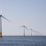
Offshore wind resource assessment relies on complementary data sources and modelling approaches. By combining satellite-based wind mapping, floating LiDAR measurements and high-resolution numerical modelling, METEODYN and CLS Group support developers in better understanding offshore wind conditions, from early-stage screening to advanced project assessment.
SARWind® – Satellite-based offshore wind data
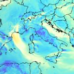
This solution combines CLS Group’s satellite expertise with METEODYN’s wind resource modelling know-how. By utilizing SAR (Synthetic Aperture Radar) technology, SARWind® provides high-resolution wind maps to characterize wind availability over large offshore areas. It is an ideal tool to reduce uncertainty in locations where in-situ data is scarce or non-existent.
Met Mast powered by CFD – High resolution virtual wind data
Through our Wind Data Portal, you can access very high-resolution, precisely geolocated wind data for onshore and offshore projects. Designed to support early-stage assessment, prospecting and feasibility phases, Virtual CFD-Met Mast data helps you obtain site-specific wind information before on-site measurements are available.
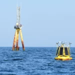
DeepCLiDAR – Certified floating LiDAR solution
DeepCLiDAR is CLS Group’s next-generation floating LiDAR solution for offshore wind projects. Designed to deliver investment-grade wind profile data with high accuracy and reliability, it supports robust wind resource assessment in coastal, shelf and deep-water environments, while offering a flexible alternative to traditional fixed meteorological masts.

Guillaume Vervout
Business Manager of the Offshore Product Line, METEODYN

Marie Cathelain
Offshore Wind Expert (PhD) and Technical Manager for the Offshore Product Line, METEODYN & CLS Group